- Submit News
- 501-666-6726
- [email protected]


Police celebrate Police Week 2017
June 19, 2017
Body found in drain in Unitedville identified
June 19, 2017
Posted: Monday, June 19, 2017. 8:55 am CST.
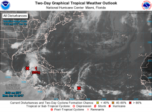
By BBN Staff: UPDATE: The low pressure system located near the east coast of the Yucatan Peninsula and Belize continues to produce a large area of disorganized showers and thunderstorms. It is producing winds up to gale force strength several hundred miles to the east and northeast of the center, which are not affecting the country.
Although surface pressures are falling over the north western Caribbean sea, the system still lacks a well-defined center of circulation.
Regardless of development, heavy rains are expected to continue over portions of Central America, and Belize. If necessary, an Air Force Reserve Hurricane Hunter aircraft is scheduled to investigate the system today.
Gradual development of this system is expected while it moves slowly north-north-westward across the Yucatan Peninsula, and then over the southern or central Gulf of Mexico today and tomorrow, where a tropical or subtropical cyclone is likely to form. This system is expected to bring moderate to heavy rainfall over the country with the heaviest rainfall likely over central, southern and some coastal areas. The concerns remain localized flooding of low-lying communities and flash floods near rivers and streams especially in the south.
- People in coastal and southern parts of the country are advised to make the necessary arrangements to protect life and property.If you are at risk to flooding be prepared to move to higher grounds before nightfall, with family or friends or to a community shelter and check on family members and neighbors who might be in need of assistance.
- If you live on the cayes and along the coast review your evacuation plan and be prepared to evacuate when advised.Review your family emergency plan. Keep handy, a first aid kit, basic tools, lanterns, batteries, flashlights, and non-perishable foods. Keep an extra supply of medication.
- Secure at least three days’ supply of food and water. Plan for one gallon of drinking water per person per day.Always remember to trim trees and secure your roof, windows and doors. Safeguard your important documents and make plans for your pet. Animals are not permitted in public shelters.
- Farmers must have a plan to secure their animals.Fishers are urged to listen to the weather bulletin before going to sea. Do not wait until it’s too late to take action. Saving your life and property are first and foremost your responsibility.
- Drivers are asked to drive with extreme care to avoid accidents due to slippery road conditions.
NEMO emergency coordinators can be reached as follows:
- Corozal, Williard Levy at 623 0237;
- Orange Walk, Suliema Celiz at 605 5046, or Aragon at 636 6094;
- Belize District, Lionel Tillett at 6154834 and Kevin Pollard at 621 2275;
- San Pedro, Vanessa Parham at 632 3698;
- Belize City, Timrose Augustine at 600 8672; and Belize City Council Liaison Officer to NEMO, Councillor Willoughby at 6309793
- Belmopan, Clare Moody at 630 9791;
- Cayo, Al Westby at 630 3224 or Johnny Ramclam at 625 2526;
- Stann Creek, Keith Emmanuel at 615 9711; and
- Toledo, Kenton Parham at 630 9787.
- The NEMO Emergency Hotline is 936. You can also get updates at hydromet.gov.bz and nemo.org.bz
The public is asked to continue to pay close attention only to the official reports and advisories and remain alert.
Advertise with the mоѕt vіѕіtеd nеwѕ ѕіtе іn Belize ~ We offer fully customizable and flexible digital marketing packages. Your content is delivered instantly to thousands of users in Belize and abroad! Contact us at mаrkеtіng@brеаkіngbеlіzеnеwѕ.соm or call us at 501-612-0315.
© 2017 – 2021, BreakingBelizeNews.com. Content is copyrighted and requires written permission for reprinting in online or print media. Theft of content without permission/payment is punishable by law.


Comments