- Submit News
- 501-666-6726
- [email protected]


Police shares info on how they intercepted drug plane
September 10, 2018COMPOL: Police officer arrested in drug plane bust not involved in Narco-Trafficking
September 11, 2018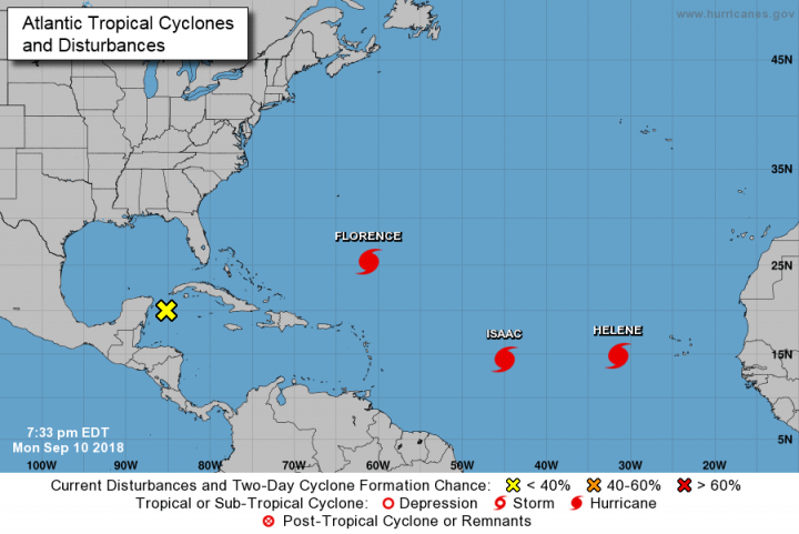
Posted: Monday, September 10, 2018. 6:32 pm CST.
Florence is now a Category 4 hurricane. Florence is growing in size and strength.
Interests in the southeastern and mid Atlantic states should monitor the progress of Florence. Florence is moving toward the west-northwest at 13 miles per hour.
On the forecast track, the center of Florence will move over the southwestern Atlantic Ocean between Bermuda and the Bahamas Tuesday and Wednesday, and approach the coast of South Carolina or North Carolina on Thursday.
Helene is a category 2 Hurricane. Helene is forecasted to turn northwestward over the Eastern Atlantic in the coming days. Some strengthening is possible during the next 12 to 24 hours, but gradual weakening should begin thereafter.
There are no coastal watches or warnings in effect.
Hurricane Isaac is located over the central tropical Atlantic ocean. Isaac is a small hurricane. Hurricane-force winds extend outward up to 10 miles (20 km) from the center and tropical-storm-force winds extend outward up to 45 miles (75 km). Isaac is moving toward the west near 14 mph (22 km/h). A westward motion with a slight increase in forward speed is expected through the end of the week. On the forecast track, Isaac should move across the Lesser Antilles and into the eastern Caribbean Sea on Thursday.
Tropical Storm Paul is also being monitored in the Atlantic ocean. Paul is expected to weaken to a tropical depression tonight. The tropical storm is expected to move west-northwestward starting tonight and continuing through Thursday.
Another disturbance is also being closely monitored in the Caribbean Sea.
Showers and thunderstorms over the northwestern Caribbean Sea and western Cuba, associated with a surface trough, are showing some signs of organization.
This system is forecast to move slowly northwestward near the Yucatan Peninsula on Tuesday with limited development.
Upper-level winds are forecast to become more conducive for development on Wednesday when the system moves over the southern Gulf of Mexico, and a tropical depression could form on Thursday or Friday while the disturbance moves across the western Gulf of Mexico.
Regardless of development, heavy rainfall and gusty winds are likely over western Cuba through Tuesday. There is a 50 percent change of development over the next 5 days.
Breaking Belize News will continue to update you with weather conditions in the Atlantic Ocean.
Advertise with the mоѕt vіѕіtеd nеwѕ ѕіtе іn Belize ~ We offer fully customizable and flexible digital marketing packages. Your content is delivered instantly to thousands of users in Belize and abroad! Contact us at mаrkеtіng@brеаkіngbеlіzеnеwѕ.соm or call us at 501-612-0315.
© 2018, BreakingBelizeNews.com. Content is copyrighted and requires written permission for reprinting in online or print media. Theft of content without permission/payment is punishable by law.


Comments